Winter Salt Snapshot 2026
- It’s time for citizen science! We need data from across the Perkiomen Watershed as part of an area-wide effort to better understand how much road salt is getting into our water.
- It’s easy to get involved! Sample your stream on Friday, January 30th, bring the sample to the Montgomery County Extension office from 3:00-7:00PM on the 30th, and we’ll test it with you.
- As in years past, PVTU is sampling the upper reaches of the Perkiomen Creek, some of its tributaries, and the West Branch. In addition, you are welcome to sample any portion of the Perkiomen Creek Watershed.
- If interested or have questions, please contact Eric Frankhouser (frankposts49@gmail.com, 267-261-3512) or Dave Deming (jknife632@gmail.com, 412-477-3926).
The details:
Road salt damages infrastructure, threatens the health of lakes and streams, and degrades drinking water. Road salt pollution has been a subject of both scientific investigations and public engagement for over 20 years, with some of the oldest studies dating back to the early days of the Clean Water Act. Stroud Water Research Center is coordinating stream and river sampling events across Pennsylvania for Winter Salt Awareness Week 2026, January 26-30.
On January 30, 2026, the Montgomery County Master Watershed Steward program and Perkiomen Valley Trout Unlimited Chapter are participating in Stroud’s Salt Snapshot. We want you to join by collecting a water sample from your local stream on that day, and then meeting at the Montgomery Extension office in the evening to analyze your samples, and enjoy snacks! See here for more information about Stroud’s annual Winter Snapshot:
Full sampling instructions:
- You will need the following:
- A sealable plastic, glass, or metal container. A used plastic water bottle works well.
- A piece of masking tape, or painter’s tape, and a marker or pen.
- Proper personal equipment for taking a stream sample (waterproof boots, proper clothing, etc.)
- Winter stream sampling can be dangerous depending on environmental and stream conditions, water temperature, etc. It is suggested that you take samples with another person, or let someone know where you are going, when you are going, and when you plan to return.
Here is a video to show you how to take samples:
One aspect of Citizen Science is that all testing is done the same way by all participants. To help insure we are all doing it the same way, or as close as possible, please watch this video prior to sampling.
Sampling summary:
- Anytime during the day on January 30, 2026, collect at least one water sample from your local stream. (Feel free to collect multiple samples from different sites if you have time.)
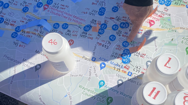
- In order to help us and Stroud provide the best coverage of sampling the Perkiomen Watershed for salt, please select a location from this map.
Simply click on a blue pin on the map for more information about that sampling location (red checkmarks have already been selected for sampling). If there are no locations on the map that you can sample from, feel free to choose your own location within the Perkiomen Watershed; just remember to record the information shown below. Let Eric Frankhouser (frankgen6@gmail.com) know which location(s) you have selected so we can mark the location(s) as selected.
- In some cases, the Sampling Location Map provides approximate locations to sample. In the days leading up to the sampling, it is strongly recommended that you visit the site(s) you plan to take samples from to insure there is safe and legal access, and to determine the best spot to sample.
After collecting the sample: - Attach a piece of masking tape or painter’s tape to the outside of the container and record the site id and location of where you took the sample. Site ids are located on the map referenced above, and on this spreadsheet (Sampling Location Spreadsheet). You may want to print the Sampling Location Spreadsheet and bring it with you when you take samples, and/or when you scout sites in advance. For locations, street address is ok, but longitude/latitude are best.
- See here on how to determine the GPS longitude/latitude of your sampling location(s)
- Bring the sample to the Montgomery County Extension Office (aka “Headquarters” – 1015 Bridge Rd, Collegeville, PA 19426) that evening from 3:00-7:00PM. We’ll have snacks and beverages available. And we’ll teach you how to analyze your sample water for chloride and conductivity.
We will record all the results and share them with Stroud Water Research to aid their research into salt pollution in our waterways. And we’ll share the data with our MWS/PVTU volunteers.
Stroud Water Research Center has seen the impact of their science magnified when participants recognize they are not alone but are part of a larger effort to address a significant environmental challenge. This includes the impacts that road salt can have on our freshwater ecosystems, including our local streams.
Questions: please email MWS Eric Frankhouser at frankgen6@gmail.com.